Coordinates without a visual reference
UTM coordinates tell you the exact position of a point, but plotting them manually before understanding the surrounding area adds another step to the workflow.
Turn survey coordinates and projects into a clear spatial picture. Locate UTM points, view project boundaries, and see where your work is concentrated on the map.
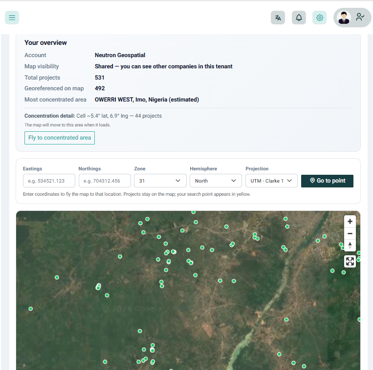
Coordinates are precise, but they do not always give you an immediate picture of where a project sits. When projects are spread across different locations, it can also be difficult to see patterns in your work without putting everything on a map.
UTM coordinates tell you the exact position of a point, but plotting them manually before understanding the surrounding area adds another step to the workflow.
When your survey jobs live in separate records, it is difficult to see your entire project portfolio spatially or understand where your work is concentrated.
Without a spatial view of your projects, opportunities to identify active work areas, project clusters, and geographic patterns can easily remain hidden.
Access the Spatial Map from your Geoflow workspace and explore your survey projects geographically.
Enter or work with UTM coordinates and see where the point falls on the map.
Visualise your projects and their locations together to understand where your survey work is happening.
See areas where projects are clustered and understand the geographic spread of your work at a glance.
Plot UTM coordinates directly on a map, visualise project boundaries, and see your entire project portfolio spatially in one place. Understand where individual projects sit and where your work is concentrated.
Go deeper than a feature list — each capability is built for survey operations in Nigeria.
Take local UTM coordinates and visualise their position geographically instead of working with coordinate values alone.
View projects across your workspace on one map and understand the geographic distribution of your survey work.
Identify areas where your projects are clustered and quickly see where your firm is doing the most work.
See where a project sits in relation to its surrounding area and get useful geographic context before going to site or discussing the project with a client.
Locate survey coordinates, understand project locations, and quickly see where your work sits geographically.
See your project portfolio on one map and identify areas where your firm has concentrated activity.
Get geographic context around a project before travelling to site and understand where the survey sits in the surrounding area.
“It is much easier to understand our project locations when we can see all of them on one map instead of looking through individual records.”
Explore your coordinates, projects, and geographic coverage with Spatial Map in Geoflow.